
Off the charts now 54 degrees !!!!!! That 129.2 for the Yanks viewing.
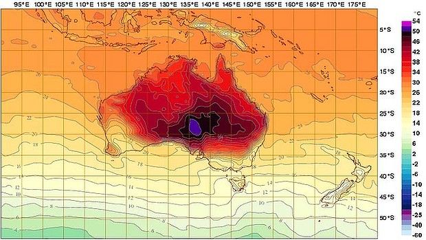
The range now extends to 54 degrees – well above the all-time record temperature of 50.7 degrees reached on January 2, 1960 at Oodnadatta Airport in South Australia – and, perhaps worringly, the forecast outlook is starting to deploy the new colours.
"The scale has just been increased today and I would anticipate it is because the forecast coming from the bureau's model is showing temperatures in excess of 50 degrees," David Jones, head of the bureau's climate monitoring and prediction unit, said.
While recent days have seen Australian temperature maps displaying maximums ranging from 40 degrees to 48 degrees - depicted in the colour scheme as burnt orange to black – both Sunday and Monday are now showing regions likely to hit 50 degrees or more, coloured purple.
Read more: Bureau Of Meteorology Weather Chart | Deep Purple
•••
As climate warms, heat waves outpace cold snaps three to oneDavid Jones
Head of Climate Monitoring and Prediction Services at Australian Bureau of Meteorology
A total fire ban is in place across NSW and the ACT as temperatures soar.
Heatwaves like the one sweeping Australia today will become more common as the globe warms, with record high temperatures already outpacing record lows by a ratio of three to one, experts said today.
Temperatures are expected to climb past 40 degrees celsius across the country today, with authorities warning of extreme bushfire risk in NSW. Over 90 bushfires had broken out across that state by early this morning, the NSW Rural Fire Service said.
Australia had experienced six days in a row of average temperatures above 39 degrees and another two days were expected, the Bureau of Meteorology said. The previous long run of such high average temperatures was four days, set in 1973.
A long dry spell in inland Australia, fewer cold fronts and the delayed onset of the monsoon in the country’s north had helped create today’s conditions but “the other thing at play here is climate change,” said Dr David Jones, Head of Climate Monitoring and Prediction Services at the Australian Bureau of Meteorology.
“We know that inland Australia is a degree and a half hotter than it was 50 to 100 years ago. Every single day we have this background warming trend which effectively means the whole climate system operates on a higher base,” he said.
“If you look at maximum temperatures, we are now finding that the rate at which we get record high temperatures is three times faster than the rate at which we get record low temperature.”
In other words, he said, “for every record cold day we see, we get three record hot days.”
“The climate system is really strongly weighted over Australia now towards record heat… that’s quite a profound shift.”
Dr Jones said Australia “was now seeing record hot nights five times more frequently than record cold nights.”
The Bureau of Meteorology released a Special Climate Statement yesterday saying that for the last four months of 2012, “the average Australian maximum temperature was the highest on record with a national anomaly of +1.61 degrees celsius, slightly ahead of the previous record of 1.60 degrees celsius set in 2002 (national records go back to 1910).”
and the denier crowd keep rattling on in their fantasy land....
They keep records there...since 1910